Every season in Armenia, and indeed around the world, has its charm. But there really is something about spring that feels special. There are many telltale signs in Armenia that spring has arrived – cafes open up their outdoor seating again, vendors sell flowers that bloom at the start of spring, like snowdrops, the fountains in Republic Square and around Yerevan are turned on, and more and more people spend time out and about.
But to truly feel and appreciate spring, you have to get out of the city. Here are five trails around Armenia that we’ve hiked and can guarantee that you will enjoy this spring season. Be sure to download the free HIKEArmenia app to plan your hike, or visit their info center in downtown Yerevan for free hiking advice and planning assistance.


1. Flowering Lake Loop
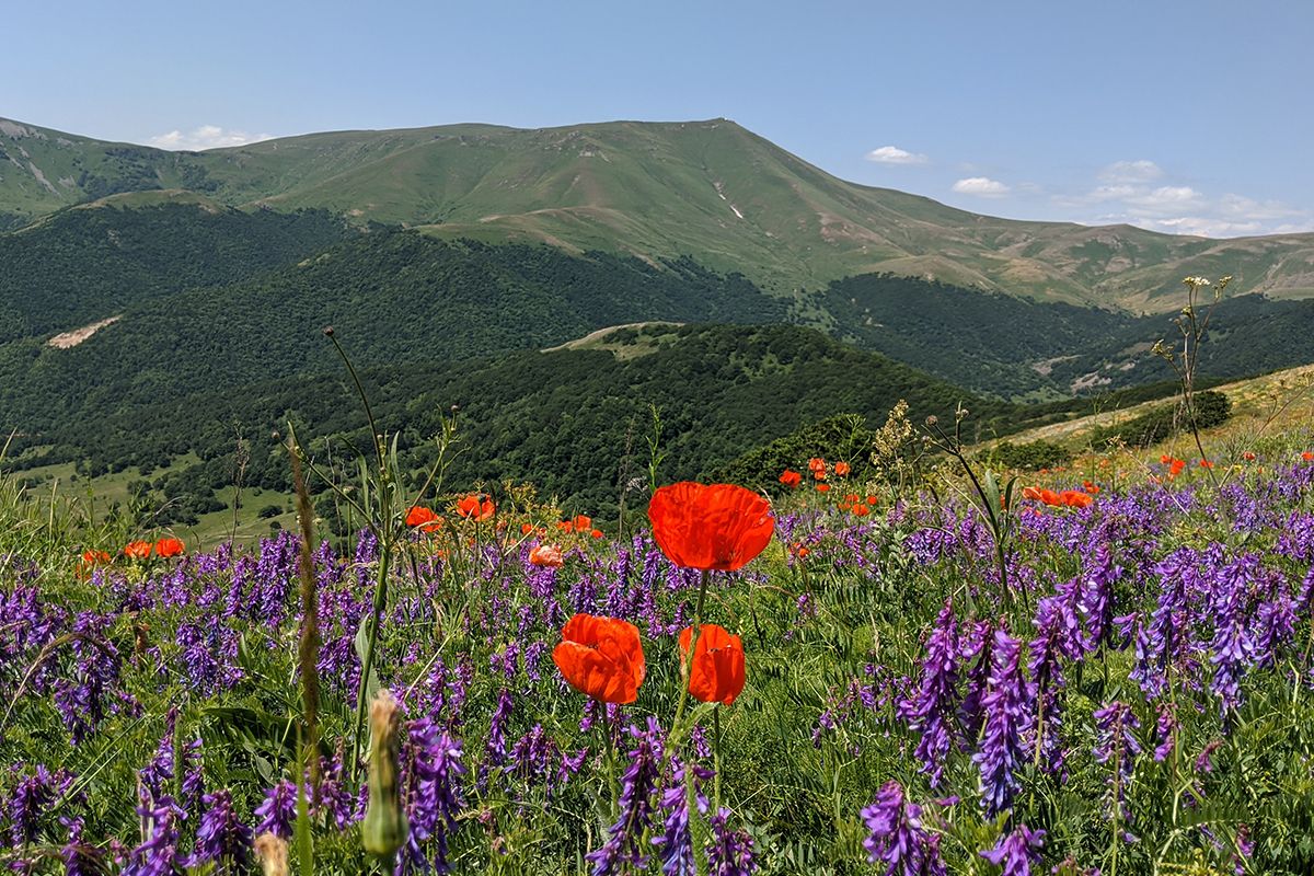
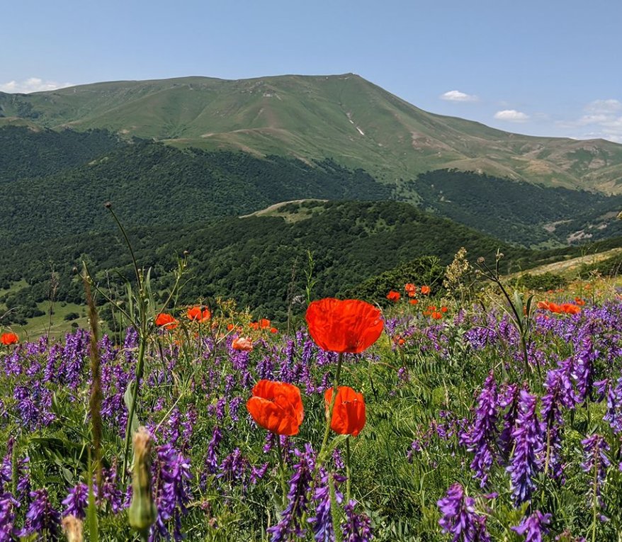
If you’re in good hiking shape and ready for a challenge, we cannot recommend hiking this trail during the spring months any more! There’s a reason why it’s called the Flowering Lake Loop. This trail takes you up high into the Tsaghkunyats Mountains to Lake Tsaghkunyats, meaning “flowering lake” in Armenian. Why, you ask? Well, between late May and early-mid June, the mountains here are quite literally blanketed with the most gorgeous display of wildflowers! If you’re a beginner hiker this may not be for you, as it’s a steep climb up as you gain 600+ meters on the loop. If you’re up for the challenge though, pack a lunch, lots of water, warm clothes, and protective gear from the sun (and a paddle board if you have one). The high elevation means cool air but also lots of direct sunlight. Definitely give yourself time for a picnic and rest when you reach the lake. We recommend doing this loop going clockwise from the trail head (heading west) as the climb up is gentler than the opposite direction.
Difficulty: Hard
Distance: 10km
Time: 5hrs
Best time of year to hike: Late May - early June
More details, including GPS track, here
2. Wildlife Oasis
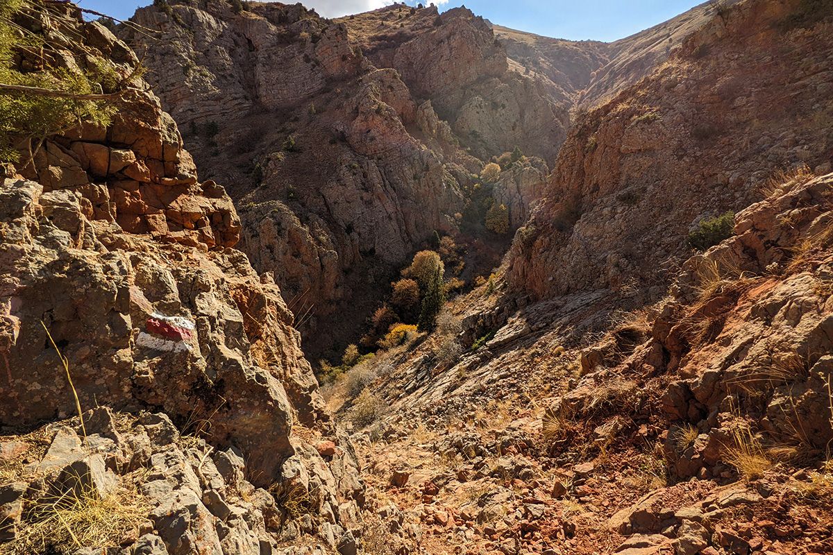
This trail takes you deep into the Noravank Canyon, also known as the Gnishik Canyon, where few travelers venture. The canyon is home to Noravank Monastery, one of Armenia’s most popular destinations, and rightly so: the monastery is a medieval architectural wonder. But the canyon and the surrounding area is also rich with its natural heritage. It’s all part of the Arpa Protected Landscape, home to an astounding 885 plant, 39 mammal, and 190 bird species. Among these creatures is the majestic bezoar goat, an endangered wild goat species native to Armenia. The best time to see these beautiful animals is at sunrise, when they come down from their caverns and other hiding places for a drink in the stream at the bottom of the canyon, but they can also be spotted in the middle of the day. They’re hard to spot with the naked eye, as they easily camouflage with the rocky cliffs where they live, but if you spot or hear rocks falling down the cliffs, it may be due to bezoar activity. Aside from the bezoar goats, you can expect beautiful wild flower blooms, and lots of butterflies when hiking this trail. A large portion of the trail has no tree cover, so go prepared with hats, sunglasses, sunscreen, and lots of water.
Difficulty: Hard
Distance: 10km
Time: 5hrs
Best time of year to hike: Late May - early June
More details, including GPS track, here
3. Cosmic Trip
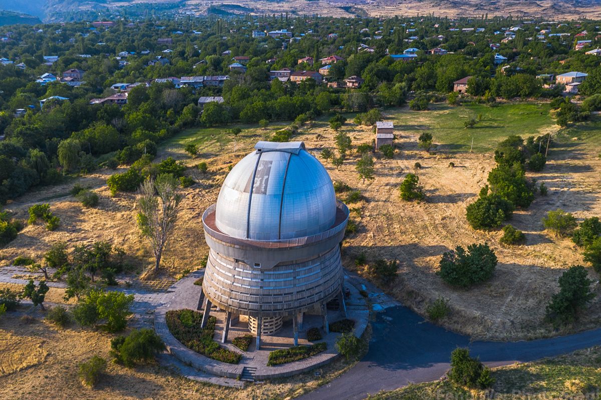
This short and relatively easy trail takes you between the villages of Byurakan and Orgov, both located on the slopes of Mt. Aragats, Armenia’s highest peak. Both villages were important science and astronomy centers back in the Soviet days, with Byurakan being home to the Byurakan Astrophysical Observatory, and Orgov being home to the Orgov Radio-Optical Telescope. This trail is special because you can pair visits to both these sites before and after your hike. The telescope at Orgov is particularly impressive – imagine a giant metallic bowl built into the earth, with a giant tower protruding up to the sky from its center. In the distance, a medieval monastery sits neatly on a cliff edge, with mighty Mt. Ararat dominating the skyline behind. It really is something to behold! Make sure you have your passport with you if you want to visit Orgov. The trail head in Orgov is located just a couple hundred meters from the road that takes you to the telescope. A guard on that road will ask to see your passports before allowing you to continue by foot to the telescope.
Difficulty: Medium
Distance: 4.3km
Time: 2.5hrs
Best time of year to hike: spring - fall months
More details, including GPS track, here
4. Oh Dam!
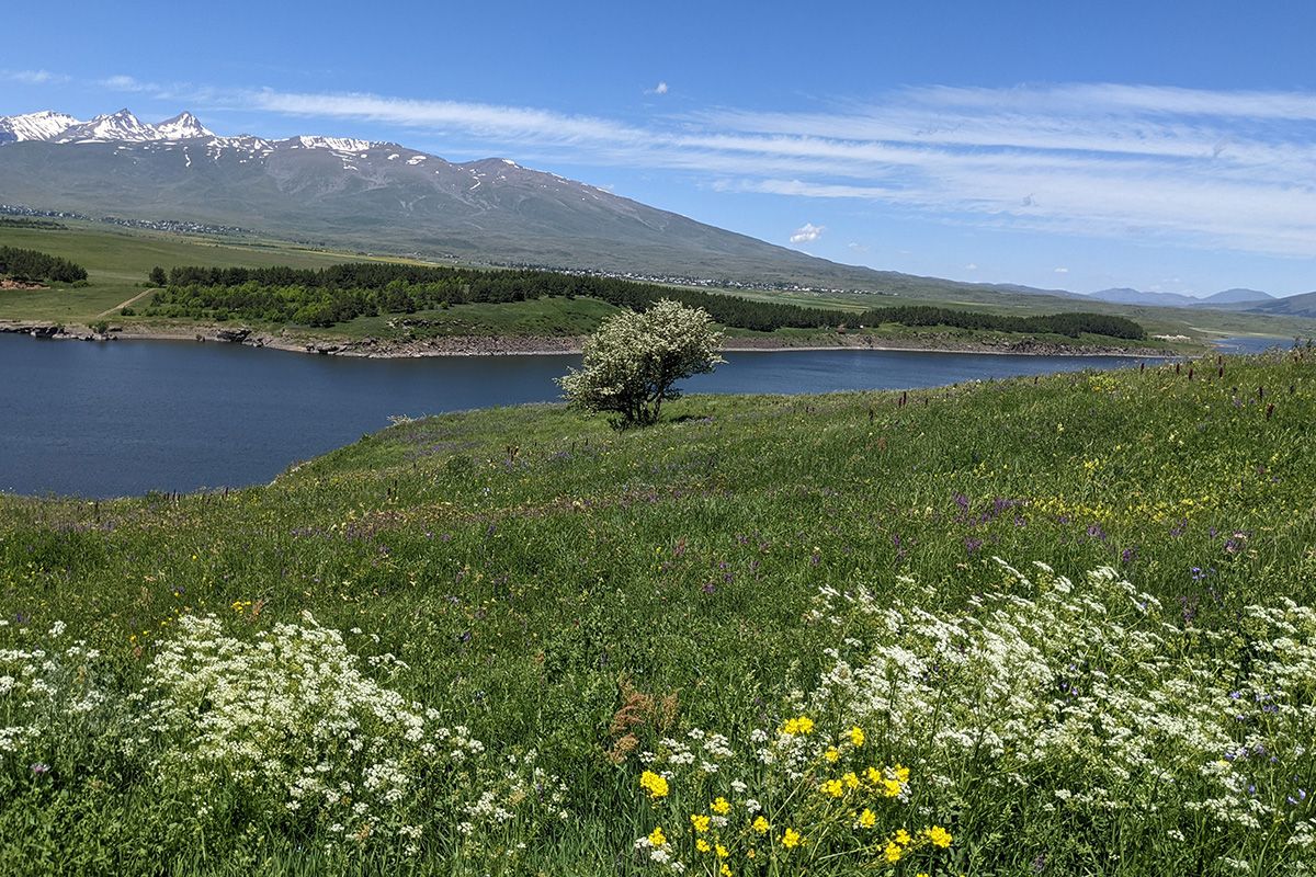
Armenia may be landlocked, but there are lots of bodies of water that dot the countryside, from lakes and rivers to reservoirs. One reservoir that’s close to Yerevan and immersed in the beautiful countryside is the Aparan Reservoir. The trail here is easy and will take you on a loop around a small forest next to the reservoir. In the spring and early summer months you can expect lots of wildflowers all along the trail. But this trail is also a great place for a winter hike as well. Just make sure you bring the right equipment like snowshoes. In the spring and summer months, we recommend taking the time for a peaceful picnic or nap in the forest overlooking the reservoir and Mt. Aragats in the distance.
Difficulty: Easy
Distance: 6.5km
Time: 3.5hrs
Best time of year to hike: year-round
More details, including GPS track, here
5. Gegharot Waterfall Trail
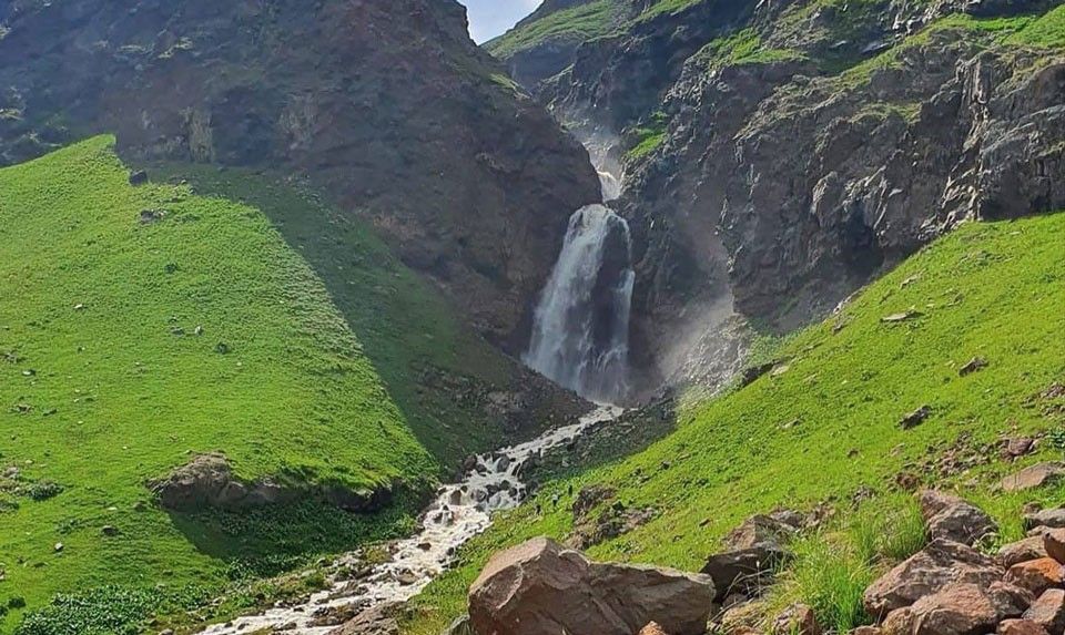
This trail may be long, and there may not be a whole lot to see along the way, but the final destination of the trail, Gegharot Waterfall, is absolutely worth it. This trail takes you deep into a valley on the slopes of Mt. Aragats. About 10kms in, you’ll enter another world of snow-capped peaks, blooming wildflowers, herds of cattle, and of course, the mighty Gegharot Waterfall. Falling from a height of 17 meters, the water is freezing cold all throughout the year. If you want to get close to the waterfall, be prepared to get wet. In the spring and summer months, you should also expect thunderstorms that come down from the summit of Aragats. Don’t miss the opportunity to visit and get to know local shepherds who live in the pastures leading up to the waterfall in makeshift tents. They’re very friendly, and just may invite you into their tent for coffee and some of the best cheese you’ll ever had, made right there on the mountain. If one of their shepherd dogs approaches you barking, don’t panic – simply slowly walk away in another direction and they’ll leave you alone.
Difficulty: Medium
Distance: 20.5km
Time: 7hrs
Best time of year to hike: late spring - late summer
More details, including GPS track, here


